Large selection of products and fast shipping guaranteed with Canpar and UPS services!
- MEN
- WOMEN
- FOOTWEAR
- BACKPACKS
- CLIMB
- HIKE
- ICE CLIMBING
- SKI
- BOOKS + MAPS
- OTHER
- SALE
- Gift cards
- BLOG
Your cart is currently empty
Product image slideshow Items
This map covers the most popular hiking and mountain biking terrain in Banff National Park, from Lake Louise in the north to the south end of Banff National Park, plus all of Mt. Assiniboine Provincial Park.
Available in store
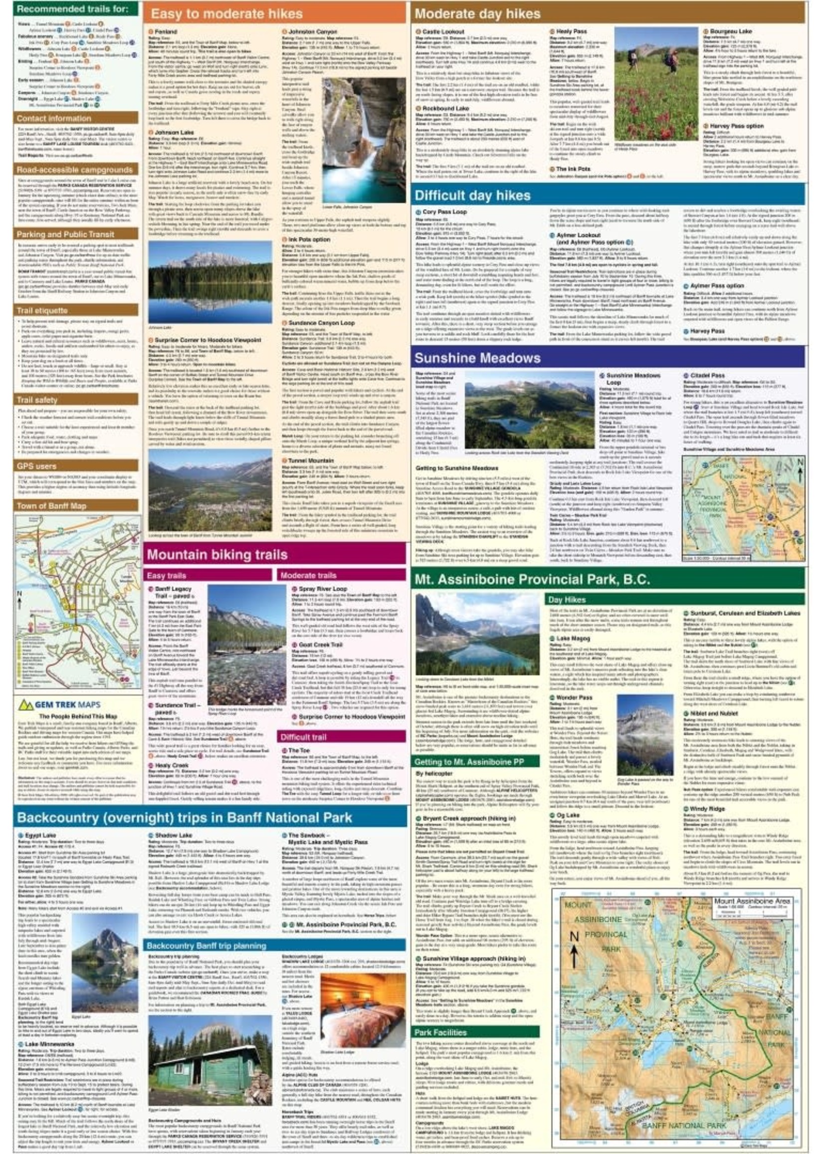
CloseGem Trek's Banff and Mount Assiniboine Map is designed for outdoor enthusiasts looking to explore the southern portion of Banff National Park and Mount Assiniboine Provincial Park. Whether you are touring along the roads or heading into the backcountry of Mount Assiniboine, you'll find the Banff and Mount Assiniboine Map to be an invaluable tool. It features detailed cartography, accurate hiking trails with distances, and details such as campgrounds, picnic areas, and lookouts. On the back are descriptions of the most popular hiking trails, including detailed descriptions of all access routes into Mount Assiniboine Provincial Park.
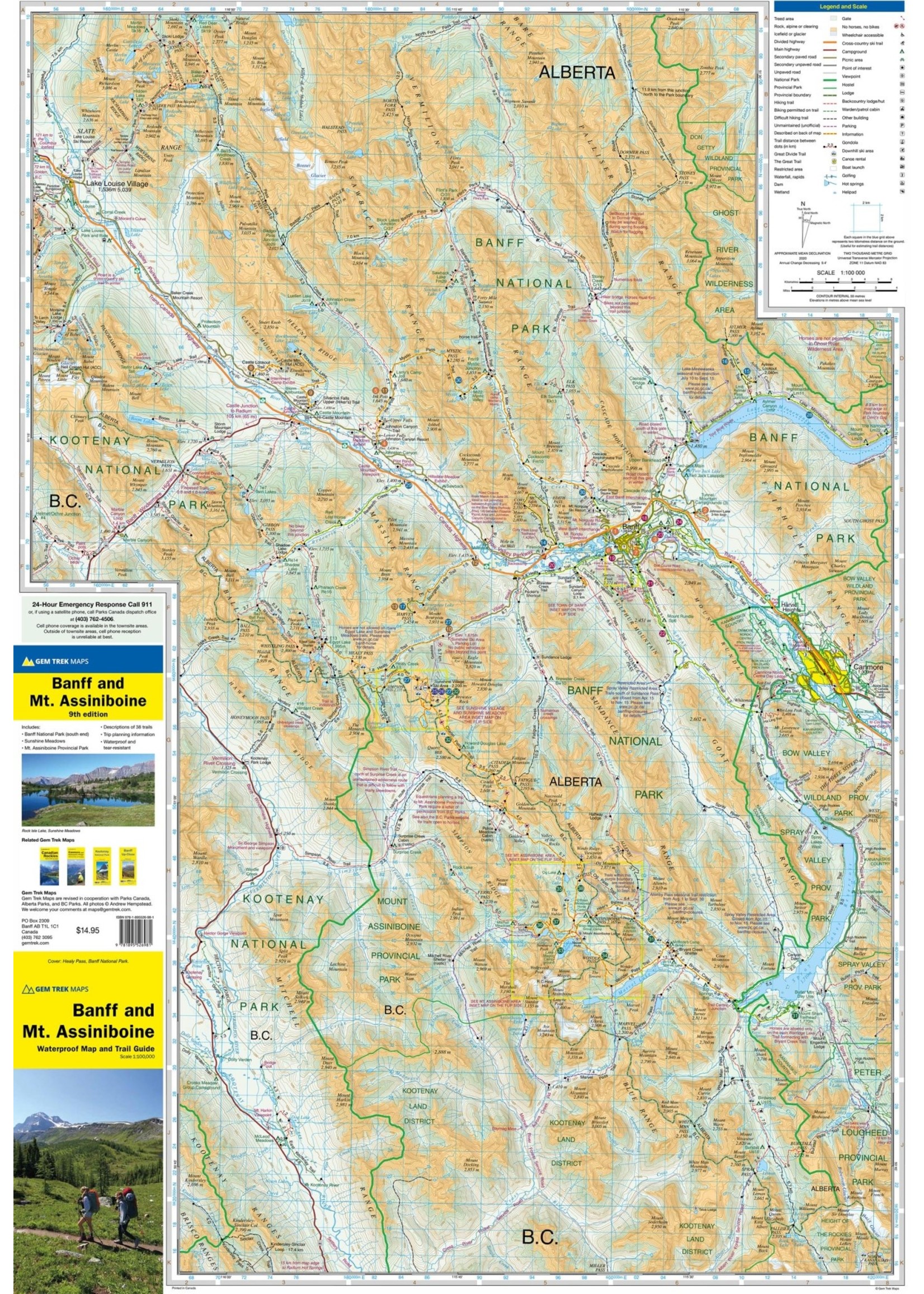
The Banff & Mount Assiniboine Map covers the southern portion of Banff National Park from Lake Louise in the north. It also includes the southern portion of the remote eastern region of Banff National Park, including trails through the remote Johnston Creek, Cascade, and Forty Mile Valleys. Popular hiking trails on the Banff & Mount Assiniboine map include Arnica Lake, Twin Lakes, Johnston Canyon, Shadow Lake, Bourgeau Lake, Sunshine Meadows, Cascade Amphitheatre, Aylmer Pass, and Spray River Loop. This map is particularly useful for visitors heading to Mount Assiniboine Provincial Park (British Columbia), which is only accessible by hiking trail or helicopter. The front of the map includes coverage of all hiking trails leading into Mount Assiniboine, including from Mount Shark, Sunshine Meadows, and Highway 93.
A 1:50,000-scale inset map on the back increases coverage of Mount Assiniboine Provincial Park, with day hikes from Lake Magog including to Wonder Pass, Windy Ridge, The Nub, and Sunburst Valley.
The Banff and Mount Assiniboine Map features:
- waterproof and tear-resistant paper
- contour lines at 25-metre (80-foot) intervals
- relief shading to better show the topography
- full colour on both sides
- hiking trails with trail names and trail distances marked
- mountain biking trails with trail names and distances marked
- hydrology rivers, rapids and waterfalls
- mountain names and all available mountain elevations
- all campgrounds with a handy chart showing campground details
- points of interest and attractions as well as picnic areas and highway viewpoints
Product carousel items

